While at this time no one can say with certainty in what manner Hurricane Matthew will affect southeastern coast of NC, it appears more likely than not that the hurricane will have an impact on the area in some manner.
 The speed at which a frontal boundary travels, which is headed our way, will be the determining factor as to how Matthew comes to visit our region. The latest plot from the WPC brings a cold front through Saturday into Sunday. That would be GREAT news because that front would push Matthew out into the ocean.
In a probable track in its Sunday afternoon update, the National Weather Service had the outer reaches of the storm hitting the east coast, at South Carolina, Friday afternoon.
The National Weather Service office in Wilmington noted in its briefing on the storm, that, no matter the final storm track, eastern North Carolina area is going to be affected by heavy rainfall, some dangerous surf with large waves, rip currents and some possible beach erosion. In addition, here is also a likelihood of coastal flooding.
Hurricane Matthew – Possible Good News:
On an encouraging note, in his 9:00am Monday morning update, Jim Cantore, with The Weather Channel, noted “F.Y.I.none of the consensus models bring it into the US.”
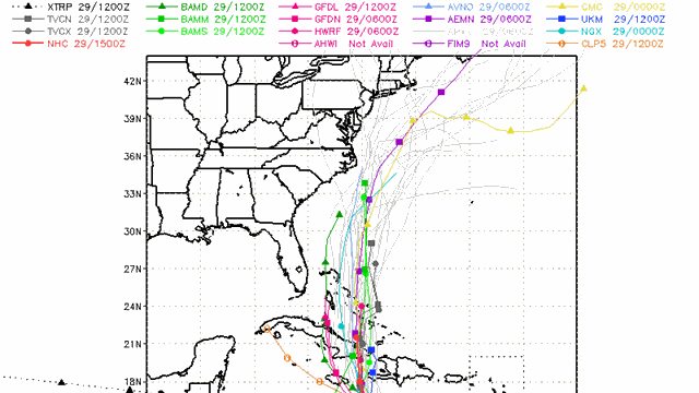 Some of the models show the storm hundreds of miles offshore which would be the best outcome but at this time it is all speculation.
The Outer Banks could see some problems even if Matthew stays out to sea. Rip currents will be a big problem Friday, Saturday, and Sunday.
Forecasters will have a much better idea on the path northward by Wednesday. By that time, the storm will have passed over Cuba which could impact the northward path significantly.